#Crowsnest Highway
Explore tagged Tumblr posts
Visit Tumblr Blog
Explore Tumblr blogs with no restrictions, modern design and the best experience.
Last Seen Tumblr Blogs


Fun Fact
Women make up for the other 50% of Tumblr’s audience.
Text


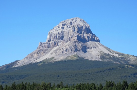


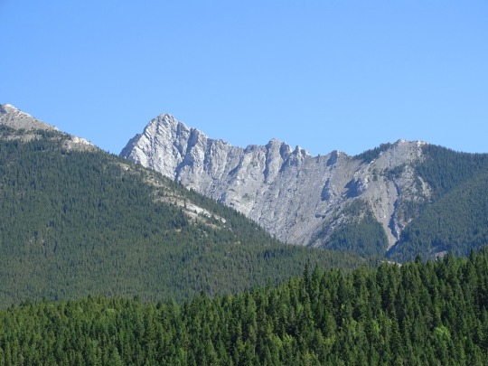
Crowsnest Highway, AB/BC
The Crowsnest Highway is an east-west highway in British Columbia and Alberta, Canada. It stretches 1,161 km (721 mi) across the southern portions of both provinces, from Hope, British Columbia to Medicine Hat, Alberta, providing the shortest highway connection between the Lower Mainland and southeast Alberta through the Canadian Rockies. Mostly two-lane, the highway was officially designated in 1932, mainly following a mid-19th-century gold rush trail originally traced out by an engineer named Edgar Dewdney. It takes its name from the Crowsnest Pass, the location at which the highway crosses the Continental Divide between British Columbia and Alberta.
In British Columbia, the highway is entirely in mountainous regions and is also known as the Southern Trans-Provincial Highway. The western-most segment between the Trans-Canada Highway and Highway 5A is locally known as the Hope-Princeton Highway, and passes by the site of the Hope Slide. In Alberta, the terrain is initially mountainous, before smoothing to foothills and eventually generally flat prairie in the vicinity of Pincher Creek. The highway forms part of the Red Coat Trail and the CANAMEX Corridor from Highway 2 near Fort Macleod to Highway 4 in Lethbridge. Many sections of the highway were built by Japanese labour while they were interned during the Second World War, including sections like the Hope-Princeton. This history has been preserved at a heritage marker at Sunshine Valley, which was the largest internment camp in Canada.
Source: Wikipedia
#Crowsnest Highway#Crowsnest Lake#Rocky Mountains#travel#original photography#vacation#tourist attraction#landmark#landscape#countryside#summer 2024#Canada#forest#Canadian Rockies#lake shore#Alberta#Alberta's Rockies#Crowsnest Pass#Crowsnest Mountain#Alison PeakMount Ward massif#Deadman Peak#British Columbia#Seven Sisters Mountain
11 notes
·
View notes
Text

Signs / Crowsnest Highway, Keremeos, British Columbia.
177 notes
·
View notes
Video
vimeo
BC Route 3 Crowsnest Highway from William F Pittock on Vimeo.
Driving Route 3, The Crowsnest Highway, from Princeton, British Columbia towards Vancouver on a perfect day.
0 notes
Video

flickr
Farmland and Mountains by Mark Stevens
#Alberta Highway 3#Blue Skies with Clouds#Canadian Rockies#Color Efex Pro#Crowsnest Highway#Day 5#Drive to Waterton AB#Farm#Farmland#Fenceline#Fences#Grassy Fields#Hwy 3#Hwy 6#Looking West#Mountains#Mountains off in Distance#Nature#Nikon D800E#Project365#Trees#Pincher Creek#Alberta#Canada#cloudy#day
17 notes
·
View notes
Text
Love and Honour in Grand Forks, British Columbia
Love and Honour in Grand Forks, British Columbia
“Twenty-six more kilometres and we are in Grand Forks,” I said as she starred blankly out the window watching the pine trees pass by in a blur. “Are we headed directly to their house?” Came my second first of three questions. The others being, would you like to stop for a coffee or ice cream and wonder how long they will want us to hang around. Neither of the last two questions were answered.…

View On WordPress
#Aaron JacksonCrabb#blue kyanite#British Columbia#Columbia and Western Rail Trail#Crowsnest Highway#elephant in the room#Granby River#Grand Forks#Kettle River#road trip#Tacoma
0 notes
Photo

Southern Canadian Rockies, Near Alberta/BC Boundary from Crowsnest Pass Highway, 1975. Not certain which province this is in, but Alberta is the most likely.
#landscape#mountains#rockies#alberta#british columbia#canada#1975#photographers on tumblr#pnw#pacific northwest
98 notes
·
View notes
Note
I’ve read your post about prickly pear and in it, you wrote you found some in the Okanagan region in BC?? Do tell me where because I attend university there! I’d love to see some prickly pears
Oh no, I am sorry – sincerely! – for not immediatelyanswering. I’m jealous that you get to attend school here; I absolutely lovecentral BC. I hope you’re still around to see this; I went to retrieve anotebook with more precise info (dates, temperature) but then failed to findit. But now that summer’s nearing and it’s a good time to go outside, I wantedto give you a couple of locations.
A few summers in a row, I saw prickly-pear near Osoyoos while looking for reptiles. I’m sure you know this already, but I love how the Okanogan Valley and Similkameen Valley act as a sort of far-northern range limit for plant and animal species more typical of the semi-arid Great Basin in the US. The rain shadow caused by the southern Coast Range and northern Cascades helps keep it dry (I’ve heard the Ashcroft area called “Canada’s only desert”). Several reptile species - racer; Great Basin gophersnake; Northern Pacific rattlesnake; desert night snake - rely on this corridor of sagebrush in the Okanogan to enter and inhabit Canada.
Anyway - here are the locations that I know of:

The Nk’mip Desert & Heritage Center, just east ofOsoyoos, is one location where I’ve seen prickly-pear (2014) and it’s very easyto access. It’s a nice place to take a stroll through some relatively intact sagebrushsteppe-type vegetation above Osoyoos Lake. (I’m not sure if there’s a feecharged nowadays for accessing the trails at the site.) There’s a chance thatstaff at the site might be a little bit picky (or “prickly”) if you wander offthe designated trails. And there’s so much human activity in the area that I don’t know if it’s a reliable place to continue to see prickly-pear.
Another location where you could check, with a little morefreedom to wander, would be the roadside along Crowsnest Highway a few mileswest of Osoyoos towards South Okanogan Grasslands Protected Area. Here, thereare two small pond/lake features – Richter Lake and Spotted Lake. They’resurrounded by pretty sagebrush. There’s not much room to walk around before you run into private land, but still.
The best location I found was along McKinney Road (2014 –2016). This is a road accessible from the town of Oliver, a little north ofOsoyoos. The road rises from sagebrush steppe through low-elevation ponderosawoodland, where I’ve seen the prickly-pear along small exposed rockoutcroppings. There are some private homes and drives along McKinney Road, butI’m pretty sure it’s fine to pull over and check the roadside for plants. (Iwas looking for lizards and snakes.) There are plenty of opportunities to pull over and check different microhabitats.
I also wouldn’t be surprised if the White Lake GrasslandsProtected Area (between Skaha Lake and Vaseux Lake, south of Penticton) hadhealthy prickly-pear, given that its climate and vegetation is similar to the Osoyoos area. But I don’t know anything about public access in that area.
I’m sorry again for the delay in answering. I hope you get to see some cactus. :)
4 notes
·
View notes
Text

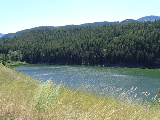


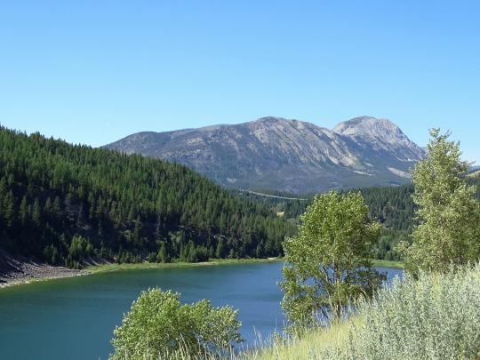


Island Lake, AB
Island Lake Provincial Recreation Area is located just west of Pinch Creek and features a small lake for fishing, boating, canoeing, or windsurfing and is home to a 40-site campground that is located within close proximity to the lake. Campsites are unserviced but suitable for RVs.
Source
#Island Lake#Island Lake Provincial Recreation Area#Rocky Mountains#travel#original photography#vacation#tourist attraction#landmark#landscape#countryside#summer 2024#Canada#forest#Canadian Rockies#lake shore#Alberta#Alberta's Rockies#Crowsnest Pass#Crowsnest Highway
6 notes
·
View notes
Photo

Had an … interesting conversation with a random stranger whose background was gravel materials and whose father was editor of Oilweek magazine in the 70’d to 90’s. I think. It was a challenge to leave but he had some interesting stories, including allusions of the “boys club” of information brokering within the 80’s oil patch, as well as stories about the mining in Canmore, Bankhead and Crowsnest Pass. Oh and the early RCMP days in Ponoka, when they did not have a regional office but had a house on highway 53 where highway officers slept between shifts while doing their patrols. Hi dads (uncles) last name was Little (?) but his last name isn’t. His name was Jim. One story was about cars moved from the auto wreckers wher the Chinook LRT station is today, dumped and buried at a Burnco gravel pit in the SE where a large house sits today. I find stories like THAT to be incredibly interesting… — view on Instagram https://ift.tt/hXSiQV4
0 notes
Text
Greetings from Alberta’s Energy Transition Corridor, Canada’s unlikely green power hotspot
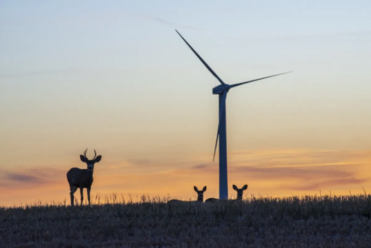
A wind turbine at sunset near the Transalta McBride Lake wind farm project near Ardenville, Alberta on October 4, 2022
Along scenic Highway 3, a multibillion-dollar renewables boom is transforming the energy landscape
As Grant Arnold strolled down the long rows of black and silver panels at his company’s solar farm near Burdett, a hamlet along Highway 3 in the south-eastern corner of Alberta, the October conditions could not have been more ideal for generating clean power. The sun beat down on the 72,500 south-facing solar panels, as a pair of miniature donkeys named Starsky and Hutch kept the facility’s groundskeepers – a herd of sheep – in line.
The Burdett Solar Farm is a new 20 megawatt facility developed by BluEarth Renewables Inc.[1], where Mr. Arnold is chief executive officer. Burdett and its sister facility, Yellow Lake, 20 km south, cover 85 hectares of farmland. BluEarth built them amid a massive influx of capital that has flowed into renewable energy along Highway 3.
These investments have made the province that’s long been known as the country’s fossil-fuel centre its green energy hot spot as well. Welcome to Alberta’s Energy Transition Corridor.
The highway cuts across a vast region that is reaping the benefits of famously bright and breezy conditions, a welcoming market for investors and big strides in green technology. Combine the space and the weather with provincial rules that allow power generators to sell directly to users, not just a government utility, and the corridor is uniquely well positioned. “It’s not happening anywhere else,” Mr. Arnold says.
Also called the Crowsnest Highway[2], the road starts at Medicine Hat in the southeast, then extends 324 km through Taber, Lethbridge, Fort Macleod and on past Pincher Creek in the Rocky Mountain foothills. From there it cuts through the Crowsnest Pass and continues west into British Columbia[3].
Along the route, signs of Alberta’s tried-and-true industrial lifeblood are everywhere – farming and ranching, food processing, cargo terminals, and oil and gas production. Day and night, heavy trucks trundle back and forth. Canadian Pacific Railway Ltd.’s tracks parallel the highway across the region’s rolling hills and badlands.
But transformation is also evident. The sunny and gusty southwestern corner of the province has been a hub for clean energy since the 1990s, and development is accelerating, with 17 projects generating 1,032 MW. Wind turbines by the hundreds poke up alongside the highway.
Lately, solar projects have popped up at a brisk pace, too. Many, like Burdett, are east of Lethbridge, developed by a variety of large and small companies. Provincewide, solar generation, at 1,088 MW, is now at the level the Alberta Electricity System Operator (AESO)[4] had forecast last year would not be reached until 2033.
Just five years ago, wind power accounted for 9 per cent of Alberta generation capacity, and solar didn’t even register, according to AESO. Today, the two sources make up 22 per cent. Solar alone is now 6 per cent of the total, and about to take its next leap when Canada’s largest solar project, Greengate Power Corp.[5]’s $700-million Travers development, starts up.
There’s also a nascent renewable natural gas (RNG) industry along Highway 3, in which the fuel is generated from agricultural and municipal waste, and plans for increased storage and other technology to level off the variable power supplies from wind and solar.
The former NDP[6] government kick-started development in 2016 with auctions in which wind developers bid on projects – those offering the least expensive power to the grid won. The arrangements have netted the Alberta government $160-million, according to new research by the University of Calgary School of Public Policy[7], and primed the pump for today’s investment rush.
“The number one driver of renewables in Alberta is private investment,” says Nagwan Al-Guneid, director of Business Renewables Centre-Canada (BRC)[8], a non-profit that provides education and networking services for developers, investors and electricity buyers. “These are private corporations, public institutions, looking to procure renewables through power purchase agreements in Alberta. They have serious ESG [environmental, social and governance] commitments.”
When BRC was established as an initiative of the Pembina Institute[9] three years ago, it set a daunting target of reaching 2 gigawatts of renewable energy contracted by 2025. Alberta has already surpassed that, after $3.75-billion in spending on new generation. All that activity, the organisation says, has created 4,500 jobs. Five deals have been signed this year, adding 333 MW of solar and wind power. More is on tap.
Green power is proliferating in other parts of the province as well. But Highway 3, already long established, can move workers and materials to and from projects quickly as they are constructed.
Most importantly, there’s “the resource” – sunshine and wind. Southern Alberta has both in spades. Lethbridge[10], for instance, averages 330 sunny days per year, or over 90 per cent of daytime hours. The region, known for its balmy Chinook winds that race across the Rockies, is also one of the breeziest in Canada, second only to St. John’s[11], according to Environment Canada. Lethbridge gets more windy days than any other city in the country.
The development has jolted local economies, which suffered with the downturn in oil and gas that began in 2014. Medicine Hat[12], known historically as The Gas City, has embraced renewables. Across southeastern Alberta, hotels are booked, restaurants are busy and the real estate market is strong, says Jon Sookocheff, economic development consultant with the city government.
Besides construction jobs, the industry is providing related opportunities, such as maintenance, warehousing and distribution. Colleges in the region are training the next generation of renewable energy technicians. “I think it’s one of the bigger development stories in Alberta and in Canada, and it’s maybe a bit of a secret right now. But it certainly takes a lot of work to put these production facilities into play,” Mr. Sookocheff says.
“All of a sudden there’s a renewables boom” for communities along Highway 3”, says Blake Shaffer, an assistant professor of economics at the University of Calgary, and a former electricity trader. “And they opened the doors to it.”
Source
JEFFREY JONES, Greetings from Alberta’s Energy Transition Corridor, Canada’s unlikely green power hotspot, in: THE GLOBE AND MAIL, 27/10/2022; https://www.theglobeandmail.com/business/article-alberta-energy-transition-corridor/
[1] BluEarth Renewables is active in select markets across Canada and the United States. Its growing portfolio of renewable energy facilities includes over 1 GW of nameplate capacity in operation, under construction, and contracted pre-construction, and over 5 GW of high-quality development projects that are actively being advanced. https://bluearthrenewables.com/
[2] The Crowsnest Highway is an east-west highway in British Columbia and Alberta, Canada. It stretches 1,161 km across the southern portions of both provinces, from Hope, British Columbia to Medicine Hat, Alberta, providing the shortest highway connection between the Lower Mainland and southeast Alberta through the Canadian Rockies. Mostly two-lane, the highway was officially designated in 1932, mainly following a mid-19th-century gold rush trail originally traced out by an engineer named Edgar Dewdney. It takes its name from the Crowsnest Pass, the location at which the highway crosses the Continental Divide between British Columbia and Alberta.
[3] In British Columbia, the Crowsnest Highway is entirely in mountainous regions and is also known as the Southern Trans-Provincial Highway. The first segment between the Trans-Canada Highway and Highway 5A is locally known as the Hope-Princeton Highway, and passes by the site of the Hope Slide. In Alberta, the terrain is initially mountainous, before smoothing to foothills and eventually generally flat prairie in the vicinity of Pincher Creek. The highway forms part of the Red Coat Trail and the CANAMEX Corridor from Highway 2 near Fort Macleod to Highway 4 in Lethbridge.
[4] The Alberta Electric System Operator, (AESO), is a not-for-profit entity responsible for the planning and operation of the Alberta Interconnected Electric System (AIES) in a "safe, reliable, and economical" manner. It is mandated by provincial legislation to act in the public interest and cannot own any transmission, distribution or generation assets.
[5] Greengate Power Corporation (Greengate) is a Canadian energy company focused on renewable energy in Alberta. Greengate's focus in the past was in large, utility scale wind projects and has recently developed solar projects.
[6] The New Democratic Party (NDP; French: Nouveau Parti démocratique, NPD) is a social democratic federal political party in Canada. The party was founded in 1961 by the Co-operative Commonwealth Federation (CCF) and the Canadian Labour Congress (CLC). On the political spectrum, the party sits to the left of the Liberal Party. The federal and provincial (or territorial) level NDPs are more integrated than other political parties in Canada, and have shared membership (except for the New Democratic Party of Quebec).
[7] The School of Public Policy is an institute at the University of Calgary located in Calgary, Alberta, Canada. Founded in 2008, The school is devoted to public policy research and education, and is led by Pierre-Gerlier Forest. Located at the University of Calgary’s downtown campus, it is home to over 60 full-time or part-time faculty and fellows. The school is organized into three policy areas: Economic and Social Policy, Energy and Environmental Policy, and International Policy. Since 2012 the school has offered a graduate degree program, the Master of Public Policy. The degree is structured as a 12-month program involving two semesters of classroom-based learning and one semester of project work.
[8] BRC-Canada is a community where buyers can learn how to source renewable energy directly from renewable energy project developers. Building on the successful experience of the Business Renewables Center in the U.S., BRC-Canada is a non-profit initiative seeking to catalyze the market for non-utility procurement in Canada to grow renewable energy development in the country. https://businessrenewables.ca/about
[9] The Pembina Institute is a Canadian think tank and registered charity focused on energy. Founded in 1985, the institute has offices in Calgary, Edmonton, Toronto, Ottawa, and Vancouver. The institute's mission is to "advance a prosperous clean energy future for Canada through credible policy solutions that support communities, the economy and a safe climate."
[10] Lethbridge is a city in the province of Alberta, Canada. With a population of 101,482 in its 2019 municipal census, Lethbridge became the fourth Alberta city to surpass 100,000 people. The nearby Canadian Rocky Mountains contribute to the city's warm summers, mild winters, and windy climate. Lethbridge lies southeast of Calgary on the Oldman River. Lethbridge is the commercial, financial, transportation and industrial centre of southern Alberta.
[11] St. John's is the capital and largest city of the Canadian province of Newfoundland and Labrador, located on the eastern tip of the Avalon Peninsula on the island of Newfoundland. The city spans 446.04 km2 and is the easternmost city in North America (excluding Greenland).
[12] Medicine Hat is a city in southeast Alberta, Canada. It is located along the South Saskatchewan River. It is approximately 169 km east of Lethbridge and 295 km southeast of Calgary. This city and the adjacent Town of Redcliff to the northwest are within Cypress County. Medicine Hat was the sixth-largest city in Alberta in 2016 with a population of 63,230. It is also the sunniest place in Canada according to Environment and Climate Change Canada, averaging 2,544 hours of sunshine a year.
0 notes
Text
March 9, 1972
MR. APPLEBY: I recall in particular the remarks that the hon. Member for Pincher Creek-Crowsnest made when he was questioning the hon. Minister of Highways, Clarence Copithorne. He brought up during the question period the matter of the "now" slogan that was part of the election platform of the party which this government now represents. And Mr. Speaker, reference to this "now" slogan was also made yesterday by the hon. member for Wetaskiwin-Leduc. I would, therefore, Mr. Speaker, like to remind these hon. gentlemen and their colleagues, as well, that on August 30th last, the people of this province indicated in a very definite and wholehearted manner their approval of the reverse of a very old slogan which was that they wished the government in this province would change from a "never" to a "now" party.
MR. DRAIN: Mr. Speaker, point of order. Is the hon. member indicating that now "now" means that --
MR. SPEAKER: Order please!
MR. DRAIN: Does the hon. member not accept "now" as meaning now, or does he have another meaning?
MR. SPEAKER: Order please.
AN HON MEMBER: Never a "now," Mr. Speaker.
#vintage alberta hansard#alberta#alberta politics#Frank Appleby#Athabasca#Charles Drain#Pincher Creek-Crowsnest#Gerard Amerongen#Edmonton-Meadowlark
0 notes
Link
Does this really need a title?
ask me a question in the comments below or by emailing them to [email protected]
This week was interesting. First off, I can finally say that I have traveled the entirety of Hwy 3, also known as “Crowsnest Highway,” from Medicine Hat, AB to Hope, BC. Now ....
If you want to read the rest of the post, which includes more about my week, and my thoughts on the movie "The Incredibles 2," you can find it here: https://www.patreon.com/posts/22359793
If you prefer, you can support me by Buying me a Kofi: https://ko-fi.com/Y8Y6BC87
1 note
·
View note
Video

flickr
Summit Lake and a View to Mount Washburn by Mark Stevens Via Flickr: I loved the view of this with the lake seemingly hidden in a mountain valley with hillsides grassy meadows all around. With breeze blowing through the pass, it just had this peaceful feel to living life.
#BC Hwy 3#Between British Columbia and Alberta#Blue Skies with Clouds#Canadian Rockies#Canvas#Color Efex Pro#Crowsnest Highway#Crowsnest Pass#Day 5#Drive to Waterton AB#Grassy Fields#Grassy Meadow#Hillsides#Hwy 3#Lake#Looking West#Mount Washburn#Mountains#Nature#Nikon D800E#Portfolio#Project365#Summit Lake#Trees#Alberta#Canada#clear#day
11 notes
·
View notes
Text
Mountain Passes and Small Town Experiences
Mountain Passes and Small Town Experiences
With Cranbrook in the rearview mirror the rain began to drizzle down on the hood of the Tacoma and we flipped on the windshield wipers and the fog lights, too. As the rain continued down highway 95 towards Yahk, we began discussing the last road trip through this same part of the countryside. “When was the last time we came through this valley?” Shauna asked. Starring down the road, my mind…

View On WordPress
#British Columbia#Castlegar#Christian Lake#Cranbrook#Creston#Crowsnest Highway#experiences#fire jumpers#Jimmy&039;s Pub & Grill#Mountain passes#road trip#trestle bridge#wildfires#Yahk
1 note
·
View note
Text


Frank Slide, AB (No. 3)
Initial news reports stated that between 50 and 60 men were within the mountain and had been buried with no hope of survival. In reality, there were 20 miners working the night shift at the time of the disaster. Three had been outside the mine and were killed by the slide. The remaining 17 were underground. They discovered that the entrance was blocked and water from the river, which had been dammed by the slide, was coming in via a secondary tunnel. They unsuccessfully tried to dig their way through the blocked entrance before one miner suggested he knew of a seam of coal that reached the surface. Working a narrow tunnel in pairs and threes, they dug through the coal for hours as the air around them became increasingly toxic. Only three men still had enough energy to continue digging when they broke through to the surface late in the afternoon. The opening was too dangerous to escape from due to falling rocks from above. Encouraged by their success, the miners cut a new shaft that broke through under an outcropping of rock that protected them from falling debris. Thirteen hours after they were buried, all 17 men emerged from the mountain.
The miners found that the row of cottages that served as their homes had been devastated and some of their families killed, seemingly at random. One found his family alive and safe in a makeshift hospital, but another emerged to discover his wife and four children had died. Fifteen-year-old Lillian Clark, working a late shift that night in the town's boarding house, had been given permission to stay overnight for the first time. She was the only member of her family to survive. Her father was working outside the mine when the slide hit, while her mother and six siblings were buried in their home. All 12 men living at the CPR work camp were killed, but 128 more who were scheduled to move into the camp the day before the slide had not arrived—the train that was supposed to take them there from Morrissey, British Columbia, failed to pick them up. The Spokane Flyer, a passenger train heading west from Lethbridge, was saved by CPR brakeman Sid Choquette, one of two men who rushed across the rock-strewn ground to warn the train that the track had been buried under the slide. Through falling rocks and a dust cloud that impaired his visibility, Choquette ran for 2 kilometres (1.2 mi) to warn the oncoming locomotive of the danger. The CPR gave him a letter of commendation and a $25 cheque (approximately $750 in 2019) in recognition of his heroism.
Source: Wikipedia
#Turtle Mountain#Frank Slide#Crowsnest Highway#Rocky Mountains#travel#original photography#vacation#tourist attraction#landmark#landscape#countryside#summer 2024#Canada#forest#Canadian Rockies#Highway 3#District of Alberta#former North-West Territories#Alberta#29 April 1903#rockslide#Alberta Highway 3#Canadian history#catastrophe
3 notes
·
View notes
Text
Scenes From a Southern B.C. Road Trip
Scenes From a Southern B.C. Road Trip
Lake of the Woods campsite in Cathedral Provincial Park Time to dodge some smoke and do some hiking, eating and driving on a road trip along the Crowsnest Highway (3) in south-central B.C. Here are some images. First stop for coffee and muffin at Bacchus Books Cafe in Golden, now owned by Katie Mitzel, author of The Skoki Cookbook Historic Studebaker and trailer at Grist Mill campground in…

View On WordPress
0 notes